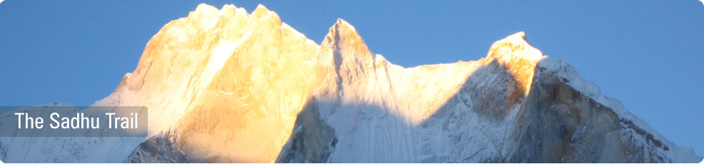
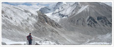
The Garhwal region offers some of the finest mountain experiences in the Himalayas and is easily accessible from Delhi. This spectacular trek takes you deep into the Central Himalayas. It is a "Sadhu" or "Monk" trail which the devotees use to cross over from Gangotri to Kedarnath, two of the holiest places of pilgrimage in India. This is one of the very few Sadhu trails left in the Himalayas. The trail passes through spectacular mountain scenery with canyons, mountains, cascading waterfalls, Pine and Birch forests and views of snow capped peaks. The views of Mount Shivling and the Bhagirathi range in the Garhwal Himalaya leave an indelible mark in the mind of those lucky enough to choose this rare trek.
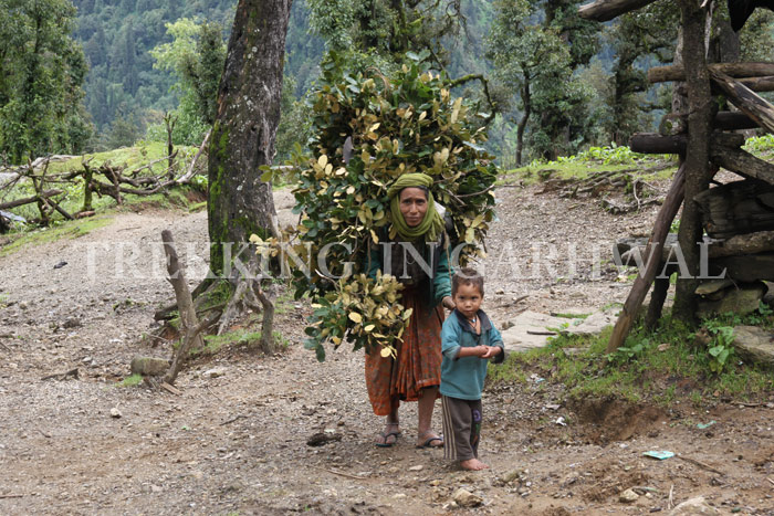
One starts with an acclimatization process before arriving at Gangotri to embark on this trek which ascends to 14,294 ft/ 4463 metres at Tapovan. This acclimatization walk is a short jaunt with the objective of passing through the foothills and untouched hill villages where the world-famous legend written by the naturalist-hunter, Jim Corbett's story of the 'Man-Eating Leopard of Rudraprayag' is based. The scenery here is unparalleled giving commanding views of the main peaks of the Garhwal Himalayas and taking the traveler through extensively terraced hills, pristine forests and tiny hill hamlets. The weather at this time of year is warm and sunny with clear blue skies.
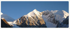
This tour has been designed to give you a comprehensive Indian experience –right from an Indian train journey across the plains, onwards to driving on twisting mountain roads through the Garhwal foothills, visiting holy Ghats, Ashrams and Temples in two of India's holiest places, Rishikesh and Haridwar and trekking to a height of 14,294 ft/ 4463 metres to get a chance to see some of the Himalayan Peaks such as Mount Shivling (20,956 ft/ 6543 metres) and Bhagirathi I, II and III (21,958 ft/ 6856 metres, 20,857 ft/ 6512 metres, and 20,671 ft/ 6454 metres respectively).
Detail Itinerary (15 Nights - 16 Days)
Day 01 : Arrival - Delhi
On arrival meet our executive and transfer to hotel. After an overnight flight, recover from jet lag by cooling off in a swimming pool , and recharging your energy. Those energetic enough to absorb the sights and sounds of Delhi, can take a dekko around town, as Delhi has a lot to offer. Overnight in hotel.
Day 02 : Delhi - Haridwar - Rishikesh (Train and Drive)
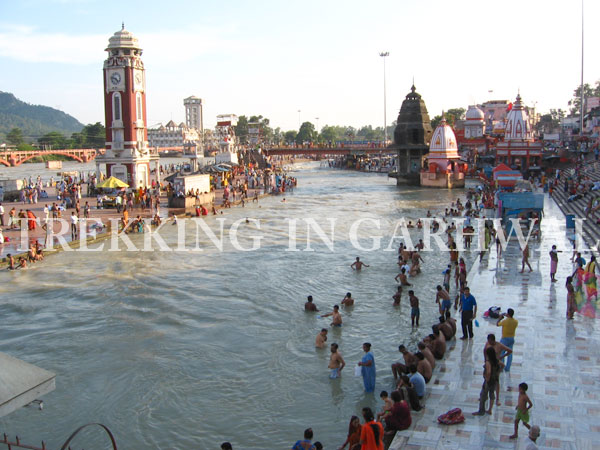
Morning transfer to the station to board the Shatabdi Express to Haridwar, one of the seven holy cities of Hinduism. The train journey takes about 51/2 hours. Legend has it that Vishnu's footprint was found on the bank of the holy river Ganges, giving it it's sanctity. Situated at the base of the Shivalik Hills, Haridwar is where the River Ganga (Ganges) passes through the last mountains and begins its 2,000 km journey across the plains of India, finally terminating at the the Bay of Bengal. The route of this life giving river (called Maa Ganga or Mother Ganges) is home to one of the most ancient civilizations in the world (other examples being the Indus river, and the Nile) in the Gangetic plains On arrival at Haridwar we will visit the town's 'steps' or 'Ghats' on the banks of the Ganges constructed for the convenience of the thousands who throng to the banks to offer prayers and dip in the sacred Ganges.. Haridwar is the gateway for pilgrims to the Hindu shrines at Badrinath, Kedarnath, Gangotri and Yamunotri further up in the mountains. So important are these destinations, that the desire and sacred duty of every Hindu is to visit these sacred shrines before his/ her demise, in order to attain salvation.
Every twelve years, when Venus and Jupiter coincide with Aquarius and the Sun and Moon are in Aries and Sagittarius respectively, there takes place an event unlike any other in the world. This is the 'Kumbh' Mela, when more than a million Hindu pilgrims gather on the banks of the Ganges to bathe in its holy waters. This is the largest congregation of humans on Earth. Even in normal times there is a great deal of activity and you will see Sadhus, pilgrims, hawkers, snake charmers and people bathing in the river Ganges! Incense pervades the air and you are suddenly immersed in the experience that is India.
Drive on to Rishikesh (25 kms away) and cross the Laxman Jhoola (a suspension bridge built by the British across the river Ganges) to visit the 13-storey temple on the other side of the river and visit Triveni Ghat, Bharat Temple and the place where Lord Rama bathed at Rishi Kund. This small town is the ancient road head for all pilgrims and in season people from all over India come here to board buses leaving for the four hill shrines. The northern part of the town is called Muni-ki-Reti and refers to the shores of the river where the Rishis or Sages in ancient times meditated. Across the Ganges large, well-maintained Ashrams teach Yoga and publish books on the Hindu scriptures. Overnight in hotel at Rishikesh.
Every twelve years, when Venus and Jupiter coincide with Aquarius and the Sun and Moon are in Aries and Sagittarius respectively, there takes place an event unlike any other in the world. This is the 'Kumbh' Mela, when more than a million Hindu pilgrims gather on the banks of the Ganges to bathe in its holy waters. Even in normal times there is a great deal of activity and you will see Sadhus, pilgrims, hawkers, snake charmers and people bathing in the river Ganges? Incense pervades the air and you are suddenly immersed in the experience that is India.
Day 03: Drive via Srinagar to Gholtir (2,116 ft/ 645 metres) and trek to Kothki Sam (2083 ft/ 635 metres) (2 hours' drive time, 1 hour trekking).
About an hour's drive from Srinagar takes one to Gulabrai, just before Rudraprayag. This is the place where Jim Corbett made his famous 'Shot in the dark' and killed the Man-Eating Leopard of Rudraprayag. Here there is a commemorative plaque on the exact spot below the tree where Corbett established the Machan and killed the notorious leopard reputed to have killed upwards of 125 people before Jim Corbett's single shot put paid to its reign of terror. Corbett stayed on his tree platform (Machan) until it was light- for fear that he had only wounded the animal that locals believed was an 'evil spirit'. Nearby is the 'Pundit's House' where you may meet Totaram- the grandson of the pundit, who was Corbett's friend. He will show you a photo of his grandfather and Corbett, and a copy of Corbett's book describing the hunt.
The road through Rudraprayag itself is noisy and congested and the staff will probably stop to buy fresh vegetables. Further down the road you will see your first views of snow-capped peaks framed in the distance. We are not far from Gholtir.
Gholtir village is situated on the left bank of the Alaknanda River. One has to cross the river over a suspension bridge and commence the trek from the right bank. The trail is flat and easy along the banks of the Alaknanda River. There is a small Hindu temple above the campsite. Time permitting, you can walk up to the village of Kothki and then descend to the river camp. This is where village festivals are occasionally held. There is a small water pumping station nearby which supplies water to the village. Overnight in tents.
Day 04 : Kothki Sam - Ishala (4593 ft/ 1400 metres/ 6 hours Trek)
The trail is fairly flat and level by the river till it climbs through terraced fields and forests to Chimka. From here there are two options - the 'short cut' is a very steep climb up to Ishala. However, the longer route is much more interesting. This route begins by a short descent to a hamlet in the valley and then climbs gradually to Kodadkhal (2,960 ft/ 925 metres), from where one can see a tree which is hundreds of years old and a living sculpture with a tangle of creepers and roots sprouting from its branches.
At Kodadkhal there is a red stone memorial to local 'Freedom Fighters' in a walled enclosure. After Kodadkhal the path climbs steadily through a Fir forest to reach a ridge from where one can see down into the next valley. Going along the ridge one finally gets to see Ishala. High mountain tops rise beyond and you can see the 'pass' with a village on the west. One has to stop at Ishala for the night. Overnight in tents.
Day 05 : Ishala - Aagar (6555 ft/ 1998 metres/ 5 hours Trek)
Initially the climb is stiff for about an hour to reach the 'pass'. The trail passes through forests with an abundance in birdlife. From the crest of the ridge there are views of giant peaks to the north, Chaukhamba (23,418 ft/ 7,138 metres), just peeping over the ridge in front . One now approaches the village of Kandi (5,508 ft/ 1,679 metres).The next village, Jagtoli (5,310ft/1,771metres) is clearly seen on the next ridge and it looks within the reach of an easy trek. We contour around past terraced fields to come up to this village astride the ridge of the mountain.
There are great views from here of two other giant peaks. To the west is Trisul (23,389 ft/ 7,066 metres) and Dunagiri (23,182 ft/ 7,066 metres). Locals say the big massif beyond is Nanda Devi but it is really hidden behind Trisul. As you enter the village there is a silver smith with a small shop. A small Hindu shrine occupies a hillock behind the houses and from here the views are spectacular. There is a school in this village with about 400 students. The trail passes this school to the ground below where one can camp for the night. One is now so high that one gets to see range after range of foothills in the distance with their terraced fields and forests. For those interested in really big birds such as the Himalayan Griffon, this is the right place to be as this area is fast gaining popularity for Vulture and Eagle sightings. Overnight in tents.
Day 06 : Aagar - Gimtoli (6391 ft / 1948 metres) and continue trek to Forest Camp (5249 ft/ 1600 metres)
It is a 5 hour trek to Aagar Pass (6,624 ft/ 2,019 metres) from where there are magestic views of Kedarnath (22,769 ft/ 6,940 metres), Kedar Dome and Chaukhamba. Looking down into the valley is the village of Gimtoli (6,503 ft/ 1,982 metres) and below that a school ground.
At Gimtoli there is a motorable road to Kanak Chauri (7,109 ft/ 2,167 metres), a small village by the road. From the village the walk up to Kartik Swami Temple (8,163 ft/ 2,488 metres) takes about an hour. This is a pleasant walk through wooded hillsides to the top of the ridge. One passes several houses occupied by Sadhus (holy men). The Temple itself was destroyed on 25 April, 1999 by an earthquake with its epicentre some 60 kms from here. This Temple has now been re-built. It sits right on top of the ridge and is the highest for miles around. Here we have the company of Lammergeyers (Gypaetus barbatus)that can be seen ridge soaring over the ridges. Returning to the road the bus ride takes one to Gimtoli descending to the village of Suwarri (5,335 ft/ 1,626 metres). The opposite hillside offers a view of path zigzagging up to the ridge. The descent for half an hour brings one to a clearing in the forest where the camp pitched for the night! Overnight in tents.
Note - it is possible to trek directly to Kartik Swami Temple from Aagar and to the forest camp without using the bus from Gimtoli. This does make a much longer day and this option can be examined with the leader at the time. The bus ride though is quite an interesting Indian experience!
Day 07 : Trek from Forest Camp to Sodi (2677 ft/ 816 metres) and drive to Rudraprayag
The trail descends downhill passing through scenic countryside and villages of Mangu and Bathwari. Next up is Deodar village.The road to Kedarnath with the Mandakani River flowing beside it can be seen from here. The vehicle ride from Sodi terminates at Rudraprayag ,the night halt. Overnight in tents.
Day 08 : Drive from Rudraprayag to Gangotri ( 10170 ft/ 3100 metres )
The drive takes one to Gangotri from Rudraprayag. One gets to see many Sadhus and other holy men with a significant number of foreigners. Legend has it that Gangotri's spectacular waterfall marks the spot where the Goddess Ganga descended from heaven in ancient times. Here Lord Shiva absorbed celestial torrent into his locks and the Ganges split into four sacred rivers - Bhagirathi, Yamanu, Mandakini and Alaknanda.
Overnight in guest house at Gangotri.
Day 09 : Trek from Gangotri to Chirbasa (11549 ft/ 3606 metres/ 4 hours)
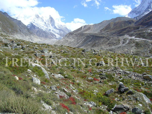
The trek begins with a gradual ascent along the surreal Bhagirathi river valley through Pine forests with towering cliffs shadowing the trek route. Enroute, one passes a check post for the Gangotri Conservation Project. The money collected here from the guide on behalf of the group goes towards projects such as collection of litter, re-planting trees and an awareness campaign for trekkers on eco-sensitive tourism. It is because of this effort that the limit of a maximum of 200 people allowed to be in the Gangotri area at one time was set . On reaching Chirbasa one establishes camp for the night, and to acclimatize to the extreme altitudes in the following days and get superb views of Manda peak (20,853 ft/ 6511 metres), Hanuman Tibba (17,186 ft/ 5366 metres), Bhrigu Parbat (19,217 ft/ 6000 metres), Bhagirathi I, II and III (21,958 ft/ 6856 metres, 20,857 ft/ 6512 metres, and 20,671 ft/ 6454 metres respectively).
Overnight in tents.
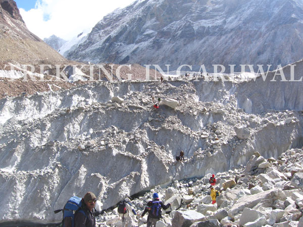
Day 10 : Trek from Chirbasa to Gaumaukh (12769 ft/ 3892 metres/ 4 hours)
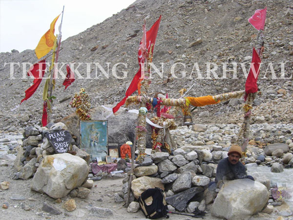
It is a two hour trek to Bhojvasa (12,145 ft/ 3792 metres) which has an Ashram, a Tourist guest house and a Police outpost. Though barren and desolate at first sight, this is a haven for wildlife and exotic flora. It is not rare to spot large herds of Himalayan Ibex, and if lucky, one might even get to catch a fleeting glimpse of the elusive snow leopard! The view of the towering peak of Shivling (20,956 ft/ 6543 metres) gives one ample opportunities to take prize winning pictures of the majestic mountain! The trail from Bhojbasa to Gaumukh is a continuous yet fairly gradual ascent. The name Gaumukh is derived from the words "Gau" - cow, and "Mukh" – mouth, is so revered that Hindus believe that a dip in the freezing waters absolves them of past sins, and helps them attain “Moksha”
Overnight in tents.
Day 11 : Trek from Gaumauk to Tapovan (14294 ft/ 4463 metres/ 3 hours)
Inspite a short walk, the trek is very tiring and strenuous owing to the effect of high altitude, and the lack of oxygen. The trek begins over rocky boulders and becomes noticeably steep gradually over the rocky terrain. The glacier is covered by moraine so you do not need any technical equipment, although a stout trekking pole is definitelyuseful. The final push takes one into Tapovan (Loose translation : Forest of Meditation) meadows and view the spectacular sight all around is indeed a sight for sore eyes. The ccompany of giants, such as - Shivling, Meru, Manda, the Bhagirathi and its two sister peaks makes one feel humbled and full awe. The grassy slopes provide an ideal base for pitching tents. The surroundings are beautiful beyond description! Overnight in tents.
Day 12 : Trek from Tapovan to Chirbasa (6 hours)
Rise early to see the spectacular sight of the sunrise on the surrounding 6000 metre peaks. Shivling is undoubtedly the star of the show, commanding instant attention as it soars dramatically into the sky, dwarfing its neighbours.
Retrace your steps to Chirvasa. A steep descent down to the glacier is followed by a rocky traverse of the glacier for a second time and a gradual descent to Chirbvsa marks the end of the day. Overnight in tents.
Day 13 : Trek from Chirbasa to Gangotri and drive to Uttarkashi
A 3 hour downhill trek from Chirvasa gets one to Gangotri , and the 6 hour drive ends at Uttarkashi. This little town is situated on a wide river valley on the banks of the river Bhagirathi at an altitude of about 4,964 ft/ 1,550 metres. The temples and Ghats have names almost identical to those in Varanasi, the historical holy city in the Indian plains. The most important temple here dedicated to Shiva is known as Vishwanath Mandir. Here stands a magnificent Trishul (trident) one meter in circumference and made of copper
Uttarkashi is known for its temples dedicated to Parhsuram, Datatryea, Annapurna, Devi, Kali Bhairon and other gods and goddesses. At one time, there were 365 temples in this town.
In the olden times Kedarnath was a 12 days' trek, Gangotri 7 days, Yamunotri 5 days and Srinagar 6 days away. However, now motorable roads go to most of these places.
Uttarkashi also has a number of Ashrams for the Sanyasis and Mendicants who occupy the banks of the holy river for penance and prayers.
It is a modern town with all facilities. The Nehru Institute of Mountaineering is located here, providing a large number of technical experts in mountaineering in Uttarkashi area. Uttarkashi has developed rapidly due to the construction of the Maneri Valley Hydroelectric Project. Overnight in tents.
Day 14 : Drive from Uttarkashi to Rishikesh
The drive to Rishikesh takes about 6 hours. There will be plenty of time in the late afternoon and evening to visit the bazaars and ashrams of Rishikesh. Rishikesh is essentially a pilgrim town and the bulk of the pilgrims are simple villagers whose intense devotion give both Haridwar and Rishikesh a special atmosphere, and a taste of the “Authentic India” that continues to flow in modern times. At sundown each evening there is a spectacular "Aarti" ceremony at the side of the river, at the bathing Ghat where tiny floating butter lamps are lit and let adrift in the waters of the Ganga as an offering to the gods, and a prayer to for departed ancestors. Overnight stay at hotel.
Day 15 : Drive from Rishikesh to Delhi
After breakfast drive to delhi by car / train. On arrival at Delhi transfer to hotel. overnight stay at hotel.
Day 16 : Delhi - Departure
You will be dropped off at the airport for your flight home.
Tour & Service End.
Want to book this tour?
call us + 91-9212553109 or click here to BOOK NOW