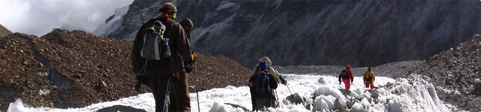
Hills of Garhwal are home of some of the finest Glaciers in India and the source of some most famous perennial rivers.Like Holy Bhagirathi,Alaknanda,Yamuna, Tons etc. The sources of all the these rivers are different Glaciers like Gaumukh for Bhagirathi, Jamundar glacier for tons rivers and Alkapuri glacier for Alaknanda river.
Every year thousand of tourists around the world come to garhwal to see these famous glaciers.
Nanda Devi Glacier :
Nanda Devi north and Nanda Devi south are two important glaciers, each with a length of approximately 19 lems. located in the Rishi Ganga river catchment. These glaciers originate on the southern slope ofNanda Devi peak (7108 m). Other important glaciers in the vicinity are Trishul, Kururntoli, Nandakna, Bartoli and Ramani. These glaciers are well developed and are large in size and length. Several melted-water streams originate from these glaciers and form the river Rishi Ganga, which later joins the Dhauli Ganga at Raini, 25 kms. from Joshimath. These glaciers are approachable from Joshimath, on the way to Malari road. Lata, about 25 kms. from Joshimath, is the last roadhead.
From Lata, a bridle path follows through a dense forest of Pine, Bhoj and other treesand alpine meadows upto Lata Kharak. From Lata Kharak the route passes through narrow gorges, steep mountain slopes and sometime through snow patches, to reach the glaciers snout.
Gangotri Glacier :
Gangotri glacier is a well-known glacier in Garhwal Himalaya, situated in Uttarkashi district. The glacier originates at the northern slope of Chaukhamba range of peaks. This is not a single valley glacier, but a combination of several other glaciers that are fed to it and form a huge mass of ice. Bhrigupanth (6772m), Kirti Stambh (6285), Sumeru Parvat (6380) respectively and Ratavana Bamak, Chaturangi Bamak and Swachand Bamak lie on the northeast slope of Srikailash, Man parvat, Satopanth and an un-namec group of peaks.
The glacier lies within a span of 28 kms. and terminates a Gaumukh (4000m).The glacier flows at a gentle slope except for a few ice walls and
crevices developed in the upper regions of the glacier where, as in the lower part (above the snout), the glacier is covered by debris which imparts a mudd appearance to its surface.
The glacier is easily approachable is well connected by motorable road upto Gangotri temple and from there a 17 kms. long bridle path follows along the right bank of the Bhagirathi river to Gaumukh, the snout of the glacier.
Lateral Glacier :
This lateral glacier situated in Tehri district is the source of river Bhilangna. The glacier is surrounded by snow peaks of the Jogin group (6466 m), Sphetic Pristwar (6905 m), Barte Kauter (6579 m) Kird Stambh (6902 m) and Meru. The moraines on the side of the glaciers look like standing walls of gravel mud.
The trek which starts from Ghuttu is easily approachable by motor from Dehradun, Tehri, Mussorie and the Rishikesh railhead. One has to trek about 45 kms. and pass through remote villages with thick Kharsao forest and wide open beautiful lush grassy meadows. The entry to the Bhilangna Valley provides excellent spots for camping. Tents and adequate provisions need to be arranged in advance from Rishikesh, Tehri and Dehradun.
Bandar Panch Glacier :
Bandarpunch is an important glacier of Yamuna river basin. The glacier is 12 kms. long situated on the northern slopes of Bandarpunch peak (6316 m), Bandarpunch west (6102m) and Khatling peak (6387m). The glacier is formed by three cirque glaciers and later join the Yamuna river. The glacier lies on a gentle slope and is bounded by lateral moraines, which indicate the last surface level of the glacier.The glacier can be approached from Dehradun to Sankri-Saur by bus and from Sankri-Saur to Taluka, 11 kms. byjeep or light vehicle, then Osia, 14 kms. From Osia Ruinsara Tal, located just below the glacier snout, is the best camping site. From Ruinsara one can visit the glacier and surrounding area.
Chorbari Bamak :
Chorbari Bamak glacier is situated in Rudraprayag District of U.P. The glacier is 6 kms. long and originates from the outhern slope of Kedar-dorne, Bhartekhunta and Kirti Stambh and this hill range is the water divide which separates the Gangotri group of glaciers and the Chorbari glacier. Several hanging glaciers and avalanche chutes feed the glacier. The lower part of the glacier is covered by thick debris and bounded by huge deposits of lateral moraines. The glacier starts from its accumulation zone (600 m) and terminates at an elevation of 3800 m, from where a snow/ice melt stream originates, called Mandakini and merges into the Alaknanda at Rudraprayag.
The glacier is approachable by roa(upto Gaurikund via Rudraprayag Guptkashi and Soneprayag. Fron Gaurikund, a foot trek runs over the hill slopes upto Kedamath Temple From Kedamath temple, there is a 3km. footpath to the glacier snout. Between the rock face and right latera moraine of the glacier, there is a lak formed by glacier melted water called Ganghi - Sarovar.
Dokriani Bamak :
Dokriani Bamak (Bamak is the local name of the glacier) is another well developed medium-sized glacier of the Bhagirathi basin. The glacier is formed by two cirques, originating at the northern slope of Draupadi-Ka-Danda and Jaonli peak, 5600 m and 6000 m respectively. The glacier is 5 km. long and flows in the northwest direction terminating at an elevation of 3800 m. The stream originating from the glacier's melted water is called Dingad which later joins many other snow/ice melted streams and finally merges into Bhagirathi river near Bukki village. There are several well-developed meadows and Proglacial lakes located 2 kms. below the snout of the glacier. These meadows, lakes and other formations themselves tell us the past history and behavior of the glacier and also provide good camping sites.
The glacier is easily approachable from Uttarkashi. Nearly 56 kms. from Uttarkashi on the road to Gangotri, Bukki village is 2 kms. from the bus terminus situated on the right bank of Bhagirathi river. On way to Dokriani glacier, one has to walk 23 kms. from the road (Bukki village). After crossing the Bhagirathi river a footpath flows along the steep mountain slopes up to Tela camp (2500 m). From Tela to Gujjar Hut a 12 km. run along the Dingad stream is a route offered to cross the several up and down ridges, many small and big streams and dense mixed forests of Deodar, Rhododendron, Oak, Pine etc. provide an atmosphere of perfect peace and tranquility. Overwhelmed by such heart-touching beauty one crosses the way without difficulties. Gujjar Hut (a summer camp ofGujjars with their buffaloes) is located at a height of 3500 m., just 5 kms. below the Dokriani Glacier. Gujjar Hut is the gateway of the valley. The valley has a gentle slope with different land features formed by the glacier and surrounded by snow- covered peaks. This place is good for camping and one can walk up to the glacier and adjoining areas and climb the small peaks. Only Gujjar huts and a base camp (near the glacier snout) of Wadia Institute ofHimalayan Geology, Dehradun lie on the way. One visiting the area has to make his own arrangement for food, tents and light warm clothes. The best season to visit is throughout summer and autumn. Besides the above two glaciers, Kedar, Rudugaira and Jaonii are some other glaciers which are approachable by the same way.
Doonagiri Glacier :
Doonagiri glacier is one of the important glaciers of Dhauli Ganga system of glaciers where more than 500 glaciers, of different shapes and sizes lie in the dee and narrow valleys. The important glaciers here are: Changbang, Girthi, Hoti an Niti glaciers, Doonagiri glacier is 5.5 kms. long, extending between an elevation from it head 5150 m to the snout 4240 m, which is the terminal point of the glacier. A stream originating from the glacier merges into Dhauli Ganga near the Jum village.
The glacier is approachable from Juma on the way to Joshimath- Malari road. 8 kms. from Juma lies the Doondgiri village. From Doonagiri village a 12 kms. long foot-trek runs along the Doonagiri stream to reach the glacier snout. Bagini is another glacier in this valley. Doonagiri is the last village in the valley. Near the vicinity of the glacier tliere is a good place for camping. The best time to visit the olace is mid Mav to mid October.
Want to book this tour?
call us + 91-9212553109 or click here to BOOK NOW